- English


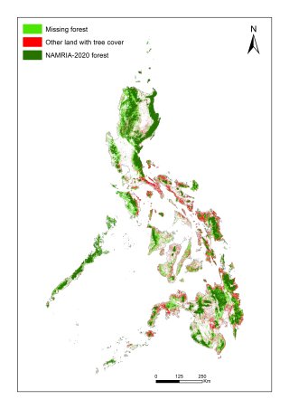
This dataset contains GIS maps (.shp files) of built-up/urban land in the Philippines in 2018 (current) and 2050 (future), considering low/medium/high future urban expansion scenarios. The 2050 urban area maps were generated using a cellular automata logistic regression model, which was applied to historical urban area maps and other openly available geospatial datasets.
More information on this dataset can be found in the journal paper entitled "High-resolution urban change modeling and flood exposure estimation at a national scale using open geospatial data: A case study of the Philippines", published in Computers, Environment and Urban Systems. Feel free to email the author ([email protected]) in case of any questions or problems with the maps.
- English