- English
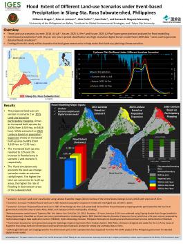


Three land-use scenarios (current: 2014 LU-Ls8, future: 2025 LU-Pm, and future: 2025 LU-Pop) were generated and analyzed for flood modelling. Event-based precipitation with 10 year rain return period classification and high resolution digital terrain model from LiDAR data5were used to generate detailed flood simulation. Findings from this study will be shared to the local government units to help make their land-use planning climate sensitive.
著者:
日付:
著作権:
トピック:
Languages:
- English