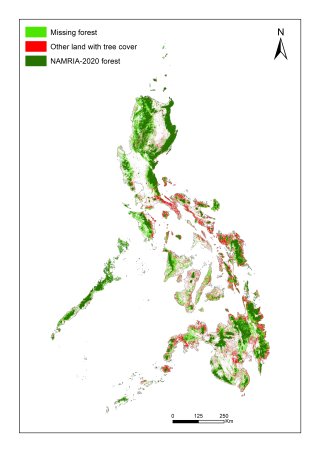
Maps of forest and other land with tree cover in the Philippines, 2020
ブックチャプター
Adopting a Transboundary Risk Management Paradigm in a World of Multi-hazard Risks
査読付論文
Advancing Flood Risk Assessment through Integrated Hazard Mapping: A Google Earth Engine-Based Approach for Comprehensive Scientific Analysis and Decision Support
査読付論文
Mapping everyday community life in suburban shrinking areas around Tokyo: case study of Minamiashigara, Kanagawa prefecture
査読付論文
Delineating dengue risk zones in Jaipur: An interdisciplinary approach to inform public health strategies