- English


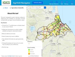
The AgriVolt Navigator is an interactive mapping tool designed to identify and analyze suitable locations for agrivoltaics—the practice of combining agricultural production with solar energy generation on the same land. The tool integrates diverse geospatial datasets, including the location of key infrastructure such as major roads, electricity transmission lines, and substations, along with land characteristics and solar potential, to help users assess where agrivoltaic systems can be effectively implemented. Through customizable, site-specific analysis using layered maps, it supports local communities—including policymakers, researchers, farmers, and clean energy developers—in advancing strategic planning and revitalizing agricultural and energy landscapes. Agrivoltaics contributes to food security, enhances grid stability, and support climate action by expanding renewable energy without competing for agricultural land.
- English